


| AQ9 - What has changed? Posted by grahame at 07:48, 9th December 2025 |     |
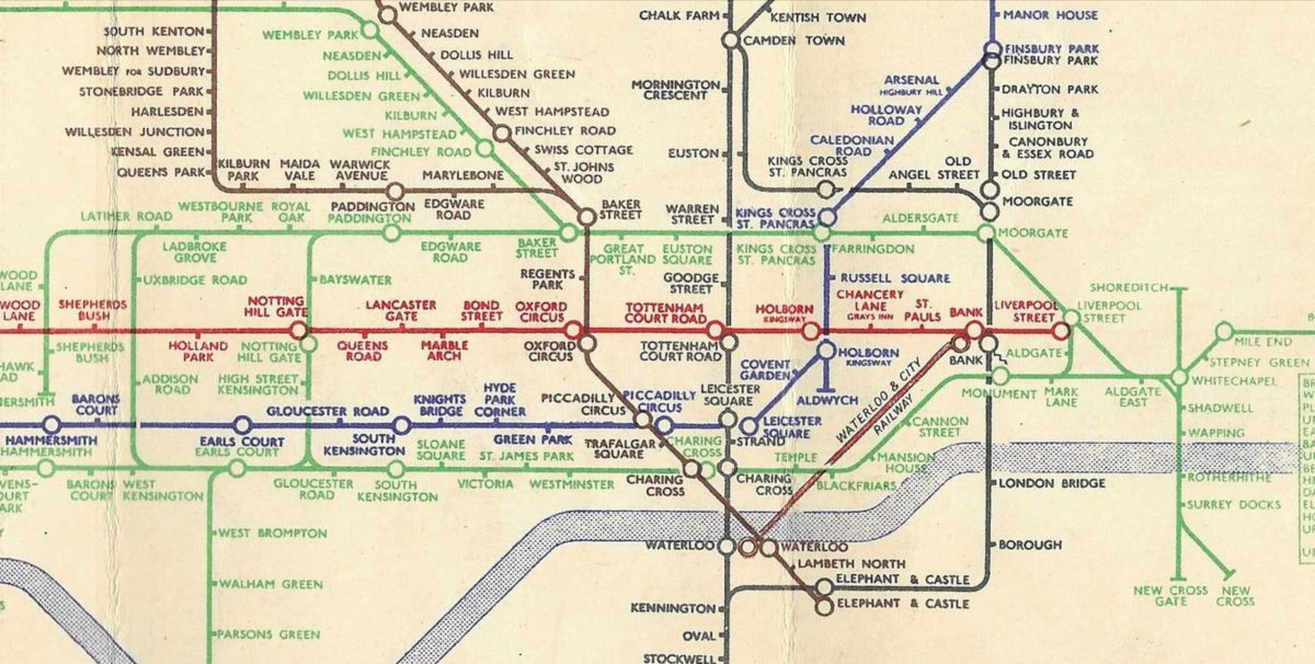
Here's an old London tube map ... although we use trains and tubes on a daily repeated basis and rely on them being the same from day to day, week to week, over time they change. Station names change. Stations are added and removed. Lines and connections are added and removed. What can you spot?
| Re: AQ9 - What has changed? Posted by ellendune at 07:55, 9th December 2025 | |
Jubilee line, taking the Bakerloo branch from Wembley Park and extending it through initially to central London via Oxford Circus and later through Waterloo and onwards into south east London.
| Re: AQ9 - What has changed? Posted by bradshaw at 08:04, 9th December 2025 | |
Charing Cross on the District line is now calked Embankment. Renamed in 1976 so that the merged Strand and Trafalgar Square stations could be called Charing Cross.
| Re: AQ9 - What has changed? Posted by Fourbee at 08:31, 9th December 2025 | |
Walham Green on the District Line is now Fulham Broadway. The old ticket hall has been repurposed: https://www.jdwetherspoon.com/pubs/walham-green-fulham/
| Re: AQ9 - What has changed? Posted by Witham Bobby at 08:57, 9th December 2025 | |
The Circle Line
Which was a "circle" of sorts, until it got cut through at Edgware Road
| Re: AQ9 - What has changed? Posted by rogerpatenall at 09:09, 9th December 2025 | |
Central line extended east from Liverpool Street
| Re: AQ9 - What has changed? Posted by Richard Fairhurst at 09:14, 9th December 2025 | |
The all-caps labels; the non-colocated circles for interchanges; the single green colour for the Metropolitan and District/Circle; the use of pull-outs (or "halos") so that a label can overlap a line (e.g. Monument); the centre alignment for multiple-line labels, even next to a vertical line (e.g. Highbury & Islington); the use of subtitles in smaller text for some stations (e.g. "Arsenal (Highbury Hill)"); concealing angles behind station interchange symbols (e.g. Mile End), which the modern Tube map never does; the stairs symbol at Monument/Bank.
Oh, and I think the whole thing is slightly out of register - the blue should be a bit up-and-to-the-left.
(I realise this is more than one answer, but I figured everyone else would be doing the factual stuff so I was clear to do the cartographical differences!
 )
)| Re: AQ9 - What has changed? Posted by Oxonhutch at 09:35, 9th December 2025 | |
The East London Line and Northern City Line now part of the Overground and National Rail. St Mary's Curve and Shoreditch gone.
No more Middle Circle - closed by the German Airborne Redevelopment Corporation.
Aldersgate now Barbican which lost its overall roof in the same era that the Middle Circle was discontinued.
Missing off the western edge of the digram is the 'Tea Run' - the one car, one station shuttle service whose return journey took the length of time it took to boil a kettle.
| Re: AQ9 - What has changed? Posted by stuving at 09:43, 9th December 2025 | |
The Circle Line
Which was a "circle" of sorts, until it got cut through at Edgware Road
Which was a "circle" of sorts, until it got cut through at Edgware Road
Not just the circle - the old Metropolitan and District Lines were split three ways, with the new Met and District lines sharing with the Circle, and with each other eastwards to Barking. Then later the Hammersmith & City was marked as a line in its own right, and the ELL taken away to be linked with the wider Overground.
| Re: AQ9 - What has changed? Posted by PrestburyRoad at 11:19, 9th December 2025 | |
Mark Lane has become Tower Hill.
Followers of Jago Hazzard's YouTube channel may have seen his video on this particular change, and he has also covered many other aspects of the evolution of the Underground. A running theme is a certain moustachioed American who is often mentioned, one Charles Tyson Yerkes - and now that I've mentioned his name I need a drink (cheers!)
| Re: AQ9 - What has changed? Posted by grahame at 20:41, 9th December 2025 | |
Some that aren't mentioned so far ...
Victoria Line
Queens Road now Queensway
Aldwych Branch closed
Met line now runs express Finchley Road to Wembley Park
Knights Bridge now Knightsbridge
Addison Road now Kensington Olympia
Shepherds Bush / Wood Lane - changes there?
| Re: AQ9 - What has changed? Posted by Oxonhutch at 21:00, 9th December 2025 | |
With Dover Street now Green Park (having moved its entrance in 1933) and Uxbridge Road being extant (or at least, on the map), I assume Graham's diagram dates within the years from the mid thirties leading up to WW2.
| Re: AQ9 - What has changed? Posted by John D at 22:41, 9th December 2025 | |
It is bit later than mid 1930s because St Mary's station wasn't closed until April 1938 (when Aldgate East was resited bit further east, so longer trains didn't foul the junction).
Uxbridge Road station and spur towards Latimer Road closed October 1940 (initially due to bombing), so might have stayed on the map longer.
