


| UK cold snap to bring sleet and hill snow over the weekend - 7 Feb 2025 Posted by Chris from Nailsea at 15:00, 7th February 2025 |     |
From BBC Weather:
A spell of colder weather has set in across the UK, with some places likely to see sleet and snow.
Friday will be a cloudier, windier day for England and Wales, with some rain showers, mainly towards the southeast. A little sleet and hill snow will also be possible over high ground. Scotland and Northern Ireland will have a sunnier, drier and less windy day. Temperatures across the UK will range between about 5 to 8C, but as a brisk easterly wind develops, a wind chill in the south will make it will feel closer to freezing.
The UK Health Security Agency (UKHSA) has issued yellow cold-health alerts for parts of northern and eastern of England, valid from 7 to 11 February. They warn of the potential for minor impacts to health and social care services.
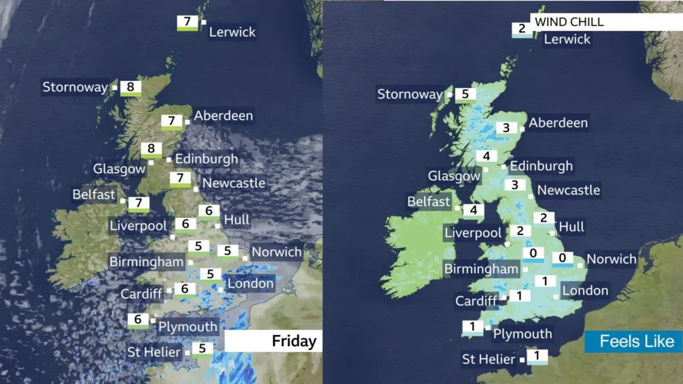
There will be a significant wind chill on Friday, making it feel several degrees colder than the thermometer suggests
For most places, we're not expecting a widespread snow event, but you may notice a few wintry flurries on Friday even to low levels in southern and eastern England. The higher chance of wintry precipitation will develop late Friday and overnight into Saturday for parts of the Midlands and east Wales.
By Saturday morning, there may be up to 5cm of snow for some places in the Brecon Beacons, eastern Cambrian Mountains and perhaps the higher parts of Exmoor. There could also be 2 to 3cm of snow for places like the Cotswolds, Chilterns, Peak District and the Pennines.

Through the weekend, some slightly less-cold air will move in for a time, especially in the south, so any impacts from snow or ice should be fairly short-lived for most.
Into next week, high pressure to the north-east of the UK will continue to bring a feed of colder air from continental Europe and temperatures are expected to be around 3 or 4 degrees below average for the time of year. Whilst most places should be predominantly dry, there is a chance of some wintry showers, especially in the east.
(Article continues)
Friday will be a cloudier, windier day for England and Wales, with some rain showers, mainly towards the southeast. A little sleet and hill snow will also be possible over high ground. Scotland and Northern Ireland will have a sunnier, drier and less windy day. Temperatures across the UK will range between about 5 to 8C, but as a brisk easterly wind develops, a wind chill in the south will make it will feel closer to freezing.
The UK Health Security Agency (UKHSA) has issued yellow cold-health alerts for parts of northern and eastern of England, valid from 7 to 11 February. They warn of the potential for minor impacts to health and social care services.
There will be a significant wind chill on Friday, making it feel several degrees colder than the thermometer suggests
For most places, we're not expecting a widespread snow event, but you may notice a few wintry flurries on Friday even to low levels in southern and eastern England. The higher chance of wintry precipitation will develop late Friday and overnight into Saturday for parts of the Midlands and east Wales.
By Saturday morning, there may be up to 5cm of snow for some places in the Brecon Beacons, eastern Cambrian Mountains and perhaps the higher parts of Exmoor. There could also be 2 to 3cm of snow for places like the Cotswolds, Chilterns, Peak District and the Pennines.
Through the weekend, some slightly less-cold air will move in for a time, especially in the south, so any impacts from snow or ice should be fairly short-lived for most.
Into next week, high pressure to the north-east of the UK will continue to bring a feed of colder air from continental Europe and temperatures are expected to be around 3 or 4 degrees below average for the time of year. Whilst most places should be predominantly dry, there is a chance of some wintry showers, especially in the east.
(Article continues)
